
WHR
Tan-yr-allt
area page
V2.5 updated 31/8/00
Click
here for images updated 24/7/00.
New text in red
Click here for J C Sreeves latest construction map
Tan-yr-allt locations
Tan-yr-allt lies along a very little used public footpath from Moel Smytho car park or from the end of the Tryfan Junction lane or from the Bryn Mair lane off the Waunfawr-Rhosgadfan lane. While a footpath does continue on alongside the line and down to the Gwredog Isaf bridge across the Afon Gwyrfai, the path north of the railway at the l/c (LC14) and underbridge (UB26) is NOT a public footpath. This is a pity as the missing 200 metres would make a nice circular walk from Tryfan Junction or Waunfawr.
Tan-yr-allt Level Crossing
(LC14)
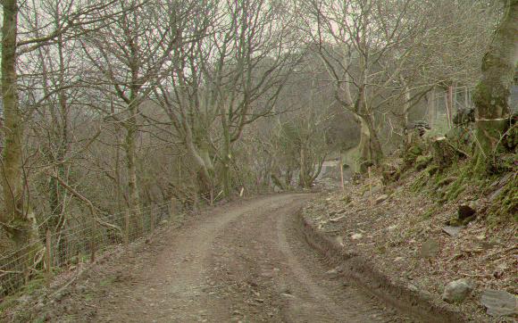
This westerly view (20/4/00) from LC14 shows the current wet state of the trackbed over the 3 km from Tryfan Junction to Waunfawr. April was the second wettest on record in Wales. The public footpath finishes at this point and visitors will have to retrace their steps. Jones has been adding large slate waste to this section to stabilise the trackbed for the passage of plant. Fine slate waste will soon be added and rolled to grade to form a sub-base for the ballast layer. Click on the image to enlarge. Slide scanned with Olympus ES10 Scanner at 200 dpi and processed with iPhoto+4 software. Image copyright B.W.Hughes.
This easterly view (20/4/00) shows the view east from LC14 with the small cattle creep UB26 in the foreground. This remains to be cleared but a water supply for cattle has been laid in for the nearby farm so the cows no longer need to go down to the Afon Gwyrfai. Click on the image to enlarge. Slide scanned with Olympus ES10 Scanner at 200 dpi and processed with iPhoto+4 software. Image copyright B.W.Hughes.
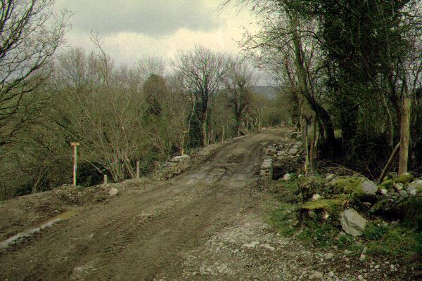
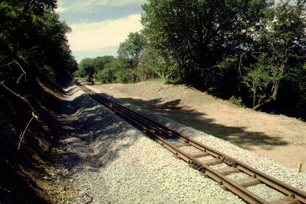
In this easterly view (18/3/00) from just east of Tan-yr-allt l/c (LC14) shows the extensive remedial works for the landslip in the distance. This is one of the sharpest curves on this section of the railway. Jones will shortly be ballasting back from this point, westwards towards Tryfan Junction. Click on the image to enlarge. Slide scanned with Olympus ES10 Scanner at 200 dpi and processed with iPhoto+4 software. Image copyright B.W.Hughes.
Tracklaying plans
Jones is currently finishing the drainage work on the 1 km length from Tryfan Junction to Tan-yr-allt (Ch 3840). They will then establish a firm base and finally ballast back from Tan-yr-allt to Tryfan Junction using the large ballast pile established at Tryfan Junction. Jones is expected to switch its attention to these tasks after completion of ballast laying from Rhostryfan Road to Caer Moel at the end of April.
Jones will then concentrate its efforts on the 2 km from Tan-yr-allt east towards Waunfawr. Release of the trackbed from Tryfan Jn. to Tan-yr-allt will allow WHRL staff to lay track east from Tryfan Jn. for 1 km.
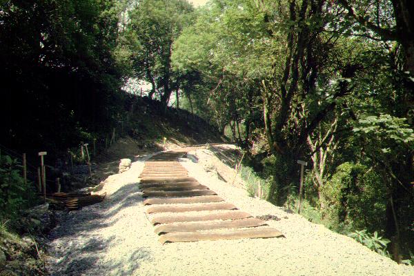
This westerly view (18/6/00?) shows sleepers laid on fresh ballast at Aspinall's Curve, just east of Tan-yr-allt l/c. Click on the image to enlarge. Slide scanned with Olympus ES10 Scanner at 200 dpi and processed with iPhoto+4 software. Image copyright B.W.Hughes.
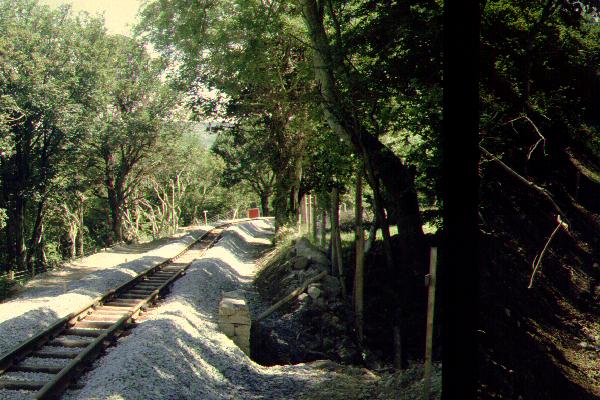
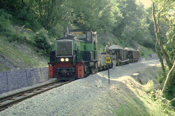
This easterly view (18/6/00) shows the track freshly laid at Tan-yr-allt l/c. The Head of Steel was just around the corner at Ch 3999 at this time. The ballast wagons have already traversed the section and lined it with ballast ready for tamping. The red square warning sign in the distance prohibits locos from proceeding beyond that point as a shortage of track bolts of one type has meant that track is not properly fixed down beyond this point. Tan-yr-allt has an underpass that descends to the right and passes under the line. Click on the image to enlarge. Slide scanned with Olympus ES10 Scanner at 200 dpi and processed with iPhoto+4 software. Image copyright B.W.Hughes.
This westerly view (18/6/00) shows the track stretching towards Gwredog bridges and Tryfan Junction. Upnor Castle has been busy bringing rails up to the location from Wernlasddu and storing them in the two-foot. Because of the difficulty of reaching this location, it will be rare to see train shots here. Click on the image to enlarge. Slide scanned with Olympus ES10 Scanner at 200 dpi and processed with iPhoto+4 software. Image copyright B.W.Hughes.
Landslip
Just east of Tan-yr-allt is the major landslip that required Jones to do additional works from January to March. Due to failure of drainage after 60 years of neglect, a section of valleyside shelf above the Afon Gwyrfai was found to be unstable. This area has several springs above the line and consists of a steep boulder clay river scar slope. Which has clearly slumped in the past. The landslip has required major works from Ch 4020 to Ch 4140 and the line is now supported up to 4 metres below the trackbed with gabions. The hillside above has also been excavated and supported with gabions up to 2 metres above the formation. Rock-fill has been added behind the gabions to increase the resistance to movement. Finally the trackbed has been reinstated with quarry waste.
Jones team was still working on the drainage in this area on 20/4/00.
The landslip area is not accessible to the public. All views of the landslip were taken on official accompanied trackbed walks or following Phase 2 induction.
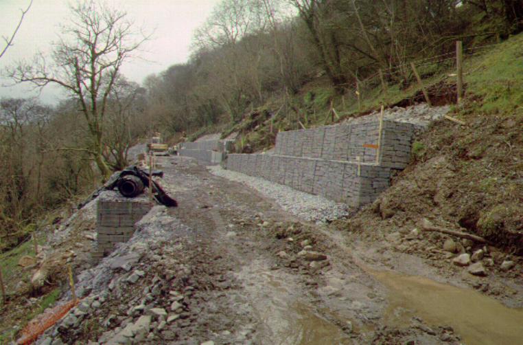
This easterly view (18/3/00) shows the substantial length of the landslip area, some 120 metres long. Double height gabions support the hillside above while in one short length, 4 layers of gabions support the line beneath the formation. Slide scanned with Olympus ES10 Scanner at 200 dpi and processed with iPhoto+4 software. Image copyright B.W.Hughes.

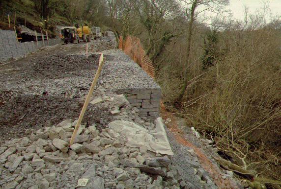
This easterly view (18/3/00) shows the stepped layers of gabions against the hillside. For aesthetic appearance, the gabions are faced with sawn slate ends while large rubble goes behind them. The slimy boulder clay that is giving rise to the problems is seen to the right. Slide scanned with Olympus ES10 Scanner at 200 dpi and processed with iPhoto+4 software. Image copyright B.W.Hughes.
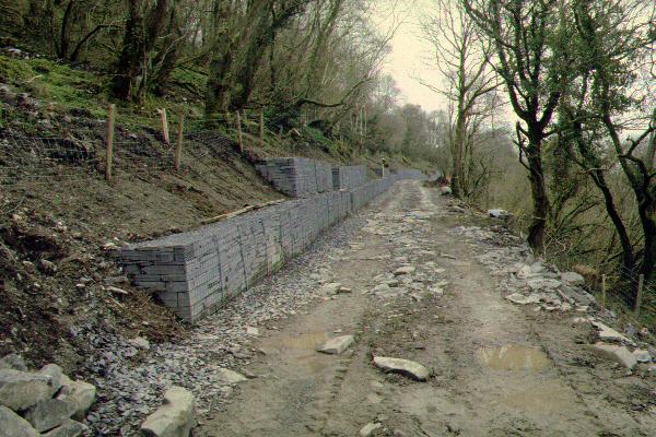
This westerly view (18/3/00) shows the short length where gabions go down four metres below the formation level to support a particularly bad patch. In the distance, Jones team is working on finishing the gabions and associated drainage works. Slide scanned with Olympus ES10 Scanner at 200 dpi and processed with iPhoto+4 software. Image copyright B.W.Hughes.
This westerly view (20/4/00) shows the east end of the landslip area with the trackbed still in original condition. Jones has finished drainage work in this area and is working east towards Cyrnant and west towards Tryfan Junction. When drainage work is complete, the rolled sub-base will be established. Click on the image to enlarge. Slide scanned with Olympus ES10 Scanner at 200 dpi and processed with iPhoto+4 software. Image copyright B.W.Hughes.
C14
This westerly view (15/7/00) shows completed track over UB 27 at Ch. 4000. This reverse curve is one of the tightest on the railway and marks the western end of the length where gabions have been employed to prevent the landslip moving again. Click on the image to enlarge. Slide scanned with Olympus ES10 Scanner at 200 dpi and processed with iPhoto+4 software. Image copyright B.W.Hughes.
C13
This easterly view (15/7/00) shows the completed tracklaying from Ch. 4000 at the west end of the landslip. Click on the image to enlarge. Slide scanned with Olympus ES10 Scanner at 200 dpi and processed with iPhoto+4 software. Image copyright B.W.Hughes.
C12
This easterly view (15/7/00) shows LC16 just east of the landslip. Wooden gates have now replaced the steel gates initially used during the construction phase. The several L/Cs in the Gwyrfai valley show little sign of use by farmers. The accommodation crossings will be finished in a similar style to that at Cae Hen. Click on the image to enlarge. Slide scanned with Olympus ES10 Scanner at 200 dpi and processed with iPhoto+4 software. Image copyright B.W.Hughes.
Click here to view next page-Cyrnant area
Click here to return to Stop Press page
Site Development
If you have suggestions for development of this site, please contact me by email.
Comments
Please add comments in my Guestbook on the homepage.
Page Version 2.5 Dated 31/8/00